Файл:Corinth, Greece (NASA).jpg

Исходный файл (2514 × 1686 пкс, размер файла: 7,43 МБ, MIME-тип: image/jpeg)
Этот файл находится на Викискладе. Сведения о нём показаны ниже.
Викисклад — централизованное хранилище для свободных файлов, используемых в проектах Викимедиа.
|
.jpg?uselang=ru)
Краткое описание
| Описание |
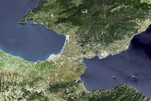
Español: Corinto y su istmo (Grecia). Foto satélite de la NASA.
English: The Isthmus of Corinth has played a very important role in the history of Greece. It is the only land bridge between the country's north (Attica) and south (Peloponnese). It is a 6 km wide tongue of land separating the Gulf of Corinth from the Saronic Sea. Populations, armies and commodities have got to move through it. In the 6th century BCE, the Greeks built the Diolkos, a 10 meter-wide stone roadway to pull ships across the Isthmus on wooden cylinders and wheeled vehicles. In 1882, a canal was started and completed 11 years later. It is 6343 meters long, 25 meters wide, and 8 meters deep.
With its 14 spectral bands from the visible to the thermal infrared wavelength region, and its high spatial resolution of 15 to 90 meters (about 50 to 300 feet), ASTER images Earth to map and monitor the changing surface of our planet. ASTER is one of five Earth-observing instruments launched December 18, 1999, on NASA's Terra satellite. The instrument was built by Japan's Ministry of Economy, Trade and Industry. A joint U.S./Japan science team is responsible for validation and calibration of the instrument and the data products. The broad spectral coverage and high spectral resolution of ASTER provides scientists in numerous disciplines with critical information for surface mapping, and monitoring of dynamic conditions and temporal change. Example applications are: monitoring glacial advances and retreats; monitoring potentially active volcanoes; identifying crop stress; determining cloud morphology and physical properties; wetlands evaluation; thermal pollution monitoring; coral reef degradation; surface temperature mapping of soils and geology; and measuring surface heat balance. The U.S. science team is located at NASA's Jet Propulsion Laboratory, Pasadena, Calif. The Terra mission is part of NASA's Science Mission Directorate.
|
| Дата | |
| Источник | https://www.flickr.com/photos/pingnews/449549729/ (see also http://photojournal.jpl.nasa.gov/catalog/PIA01919) |
| Автор | NASA/GSFC/METI/ERSDAC/JAROS, and U.S./Japan ASTER Science Team |
| Другие версии | File:Corinth ast 2005129 lrg.jpg |
Это изображение или видеозапись внесены в каталог Космического центра имени Джонсона НАСА под идентификатором (Photo ID): PIA01919. Этот шаблон не указывает на правовой статус данной работы. По-прежнему необходим нормальный шаблон лицензий. См. Commons:Лицензирование. Другие языки:
|
Лицензирование
| Этот файл находится в общественном достоянии (англ. public domain), так как он был создан NASA (Национальным управлением по аэронавтике и исследованию космического пространства). Политика авторского права NASA гласит, что «Материал NASA не защищается авторским правом, если не указано иное». (См. Template:PD-USGov, страницу политики авторского права NASA или политику использования изображений JPL.) | ||
 |
Предупреждения:
|
История файла
Нажмите на дату/время, чтобы посмотреть файл, который был загружен в тот момент.
| Дата/время | Миниатюра | Размеры | Участник | Примечание | |
|---|---|---|---|---|---|
| текущий | 00:44, 12 августа 2008 | | 2514 × 1686 (7,43 МБ) | FlickreviewR | Replacing image by its original image from Flickr |
| 17:22, 10 июля 2007 |  | 1024 × 687 (629 КБ) | Dorieo21 | {{Information |Description=Corinto y su istmo (Grecia). Foto sarélite de la NASA. |Source=http://www.flickr.com/photos/pingnews/449549729/ |Date=7 abril 2007 |Author=pingnews.com pingnews.com |Permission= |other_versions= }} |
Использование файла
Следующая страница использует этот файл:
Глобальное использование файла
Данный файл используется в следующих вики:
- Использование в arz.wikipedia.org
- Использование в ceb.wikipedia.org
- Использование в cs.wikipedia.org
- Использование в eo.wikipedia.org
- Использование в es.wikipedia.org
- Использование в fi.wikipedia.org
- Использование в fr.wikipedia.org
- Использование в hu.wikipedia.org
- Использование в it.wikipedia.org
- Использование в ja.wikipedia.org
- Использование в ka.wikipedia.org
- Использование в ko.wikipedia.org
- Использование в pl.wikipedia.org
- Использование в ro.wikipedia.org
- Использование в sv.wikipedia.org
- Использование в sw.wikipedia.org
- Использование в vls.wikipedia.org
- Использование в www.wikidata.org
.jpg)