Файл:1707 Homann and Doppelmayr Map of the Moon - Geographicus - TabulaSelenographicaMoon-doppelmayr-1707.jpg

Исходный файл (4000 × 3367 пкс, размер файла: 4,48 МБ, MIME-тип: image/jpeg)
Этот файл находится на Викискладе. Сведения о нём показаны ниже.
Викисклад — централизованное хранилище для свободных файлов, используемых в проектах Викимедиа.
|
| Автор | ||||||
| Название |
Tabula Selenographica in qua Lunarium Macularum exacta Descriptio secundum Nomenclaturam Praestantissimorum Astronomorum tam Hevelii quam Riccioli Curiosis Rei Sidereae Cultoribus exhibetur Joh. Babr. Doppelmajero Math. P.P. upera Joh. Baptistae Homanni Norinbergae. |
|||||
| Описание |
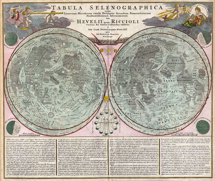
English: A stunning full color example of J. B. Homann and Johann Gabriel Doppelmayr’s important c. 1742 map of the Moon. Essentially a comparative chart, Doppelmayer constructed this map to illustrate the lunar mapping of Johannes Hevelius (left) and Giovanni Battista Riccioli (right). The left hand lunar map, composed by Hevelius, is a considered a foundational map in the science of Selenography – or lunar cartography. This map first appeared in Hevelius’ 1647 work Selenographia which laid the groundwork for most subsequent lunar cartographic studies. Here the moon is presented as it can never be seen from Earth, at a greater than 360 degrees and with all visible features given equal weight. In this map Hevelius also establishes the convention of mapping the lunar surface as if illuminated from a single source – in this case morning light. The naming conventions he set forth, which associate lunar features with terrestrial locations such as “Asia Minor”, “Persia”, “Sicilia”, and etcetera were popular until the middle of the 18th century when Riccioli’s nomenclature took precedence. The Riccioli map, on the right, is more properly known as the Riccioli-Grimaldi map, for the fellow Jesuit Francesco Grimaldi with whom Riccioli composed the chart. This map first appeared in Riccioli and Grimaldi’s 1651 Almagestum Novum . This was a significant lunar chart and offered an entirely new nomenclature which, for the most part, is still in use today. Curiously, though Riccioli, as a devout Jesuit, composed several treatises denouncing Copernican theory, he chose to name one of the Moon’s most notable features after the astronomer – perhaps suggesting that he was a secret Copernicus sympathizer? Other well-known lunar features named by Riccioli include the Sea of Tranquility where Apollo 11 landed and where Neil Armstrong became the first human to set foot on the moon’s surface. The upper left and right hand quadrants feature decorative allegorical cartouche work that include images of angelic children looking through a telescope and a representation of the ancient Greek Moon goddess Selene. Additional mini-maps show the moon in various phases of its monthly cycle. Below the map proper extensive Latin text discusses Selenography. This map first appeared in J. B. Homann’s 1707 Neuer Atlas and was later reissued as plate no. 11 in Doppelmayr’s important 1742 Atlas Coelestis , which was also published by the Nuremburg firm of Johann Baptist Homann. There is no discernable difference between the two issues and it is all but impossible to know in which of the two publications this map was drawn from. |
|||||
| Дата | 1707 или 1742 (undated) | |||||
| Размеры | высота: 20 дюймов (50,8 см); ширина: 23 дюймов (58,4 см) | |||||
| Инвентарный номер |
Geographicus link: TabulaSelenographicaMoon-doppelmayr-1707 |
|||||
| Источник/Фотограф |
Homann, J. B., Neuer Atlas bestehend in auserlesenen und allerneusten Land-Charten ueber die gantze Welt, und zwar erstlich nach Astronomischer Betrachtung der Bewegung des Himmels in dem Systemate Copernico-Hugeniano, dann auch nach der nturlichen Beschaffenheit und geographischen Eintheilung der mit Wasser umgebenen allgemeinen Erd-Kugeln in ihre besondere Monarchien, Koenigreiche, Staaten und Laender, (Nuremberg), 1707. Also in: Doppelmayr, J. G., Atlas Coelestis in quo Mundus Spectabilis et in eodem Stellarum omnium Phoenomena notabilia, circa ipsarum Lumen, Figuram, Faciem, Motum, Eclipses, Occultationes, Transitus, Magnitudines, Distantias, aliaque secundum Nic. Copernici et ex parte Tychonis de Brahe Hipothesin. Nostri intuitu, specialiter, respectu vero ad apparentias planetarum indagatu possibiles e planetis primariis, et e luna habito, generaliter e celeberrimorum astronomorum observationibus graphice descripta exhibentur, cum tabulis majoribus, (Homann, Nurenburg) 1742.
|
|||||
| Права (Повторное использование этого файла) |
|
|||||
История файла
Нажмите на дату/время, чтобы посмотреть файл, который был загружен в тот момент.
| Дата/время | Миниатюра | Размеры | Участник | Примечание | |
|---|---|---|---|---|---|
| текущий | 22:39, 24 марта 2011 | | 4000 × 3367 (4,48 МБ) | BotMultichillT | {{subst:User:Multichill/Geographicus |link=http://www.geographicus.com/P/AntiqueMap/TabulaSelenographicaMoon-doppelmayr-1707 |product_name=1707 Homann and Doppelmayr Map of the Moon |map_title=Tabula Selenographica in qua Lunarium Macularum exacta Descrip |
Использование файла
Следующая страница использует этот файл:
Глобальное использование файла
Данный файл используется в следующих вики:
- Использование в de.wikipedia.org
- Использование в de.wikisource.org
- Использование в es.wikipedia.org
- Использование в fr.wikipedia.org
- Использование в hu.wikipedia.org