Файл:Boldly going up Cerro Paranal.jpg

Исходный файл (21 464 × 2894 пкс, размер файла: 40,06 МБ, MIME-тип: image/jpeg)
Этот файл находится на Викискладе. Сведения о нём показаны ниже.
Викисклад — централизованное хранилище для свободных файлов, используемых в проектах Викимедиа.
|
Краткое описание
| Внимание! | Изображение содержит очень большое количество пикселей, и при просмотре его в полном разрешении в некоторых обозревателях могут возникнуть такие проблемы, как загрузка искажённого изображения или зависание. |
|---|
| Описание |
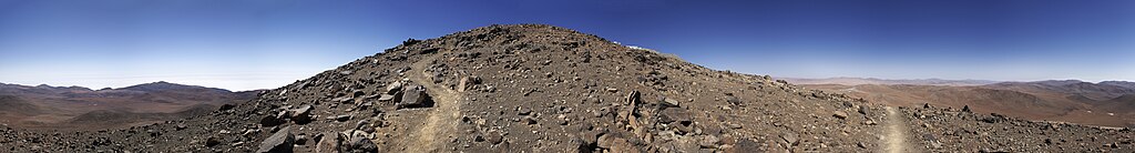
English: ESO’s Paranal Observatory facilities, such as the Residencia, give people who work at the site a welcome shelter from the surrounding inhospitable environment. In spite of that, they also offer interesting options for those who wish to enjoy the stark and silent beauty of the Atacama Desert.
Among these is the Star Track, a walking path which connects the Residencia with the Very Large Telescope (VLT) platform, on the 2600-metre summit of Cerro Paranal. Built in 2001, the Star Track covers about two kilometres in distance and a difference in height of 200 metres. The last part of the track snakes around the west side of the mountain, offering incomparable views. This 360-degree panoramic picture is centred facing north, so the right and left edges of the picture correspond to the south. To the north, the VLT control room and part of one of the Unit Telescope enclosures can just be seen peeking over a local bump in the terrain that hides most of the Paranal summit. To the west, clouds cover the Pacific Ocean, only 12 kilometres away. To the east, the facade and dome of the Residencia can be seen in the distance.Deutsch: Die Anlagen des Paranal-Observatoriums der ESO,wie beispielsweise die Residencia, geben den dort arbeitenden Menschen einen willkommenen Unterschlupf vor der unwirtlichen Umgebung. Trotz allem bieten sie interessante Möglichkeiten für jene, die die karge und stille Schönheit der Atacamawüste genießen wollen.
Darunter ist auch der “Star Track” oder “Sternenpfad”, ein Fußweg, der die Residencia mit der Plattform des Very Large Telescopes verbindet. Er verläuft bis zum Gipfel des 2600m hohen Cerro Paranal. Der Wanderweg wurde 2001 erbaut, hat eine Länge von ca. 2 km und überwindet eine Höhendifferenz von 200m. Der letzte Teil des Weges windet sich die Westseite der Berges hinauf und bietet unvergleichliche Aussichtspunkte. Dieses 360°-Panorama zeigt im Mittelteil nach Norden, somit ist die rechte und linke Bildseite nach Süden weisend ausgerichtet. Nach Norden ist der Kontrollraum des VLT und eines der Schutzgebäude des VLTs gerade noch über einem kleinen Hügel erkennbar, der die meisten Anlageteile des VLTs verdeckt. Nach Westen bedecken Wolken den Pazifik, der gerade mal 12 km entfernt liegt. In östlicher Richtung erkennt man die Fassade und die Kuppel der Residencia. |
| Дата | |
| Источник | http://www.eso.org/public/images/potw1208a/ |
| Автор | ESO/E. Emsellem |
Лицензирование
This media was created by the European Southern Observatory (ESO).
Their website states: "Unless specifically noted, the images, videos, and music distributed on the public ESO website, along with the texts of press releases, announcements, pictures of the week, blog posts and captions, are licensed under a Creative Commons Attribution 4.0 International License, and may on a non-exclusive basis be reproduced without fee provided the credit is clear and visible." To the uploader: You must provide a link (URL) to the original file and the authorship information if available. | |
Этот файл доступен по лицензии Creative Commons Attribution 4.0 International
| |
История файла
Нажмите на дату/время, чтобы посмотреть файл, который был загружен в тот момент.
| Дата/время | Миниатюра | Размеры | Участник | Примечание | |
|---|---|---|---|---|---|
| текущий | 15:13, 25 марта 2013 | 21 464 × 2894 (40,06 МБ) | Stas1995 | User created page with UploadWizard |
Использование файла
Следующая страница использует этот файл:
Глобальное использование файла
Данный файл используется в следующих вики:
- Использование в ba.wikipedia.org
- Использование в la.wikipedia.org
- Использование в te.wikipedia.org
- Использование в uz.wikipedia.org