Файл:FuehrerBunkerBerlinLocation.jpg
Исходный файл (700 × 830 пкс, размер файла: 532 КБ, MIME-тип: image/jpeg)
Этот файл находится на Викискладе. Сведения о нём показаны ниже.
Викисклад — централизованное хранилище для свободных файлов, используемых в проектах Викимедиа.
|
| Описание |
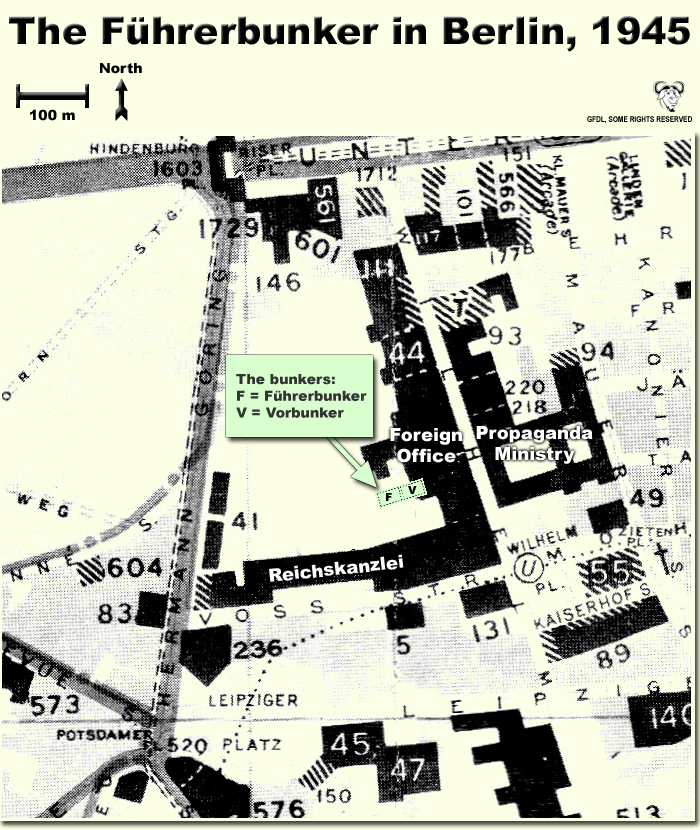
Map showing the locations of the Fuehrerbunker and Vorbunker in Berlin, 1945. |
| Дата | |
| Источник | Собственная работа |
| Автор | User:Dna-Dennis |
| Права (Повторное использование этого файла) |
CC, see below. The map is completely unrestricted for any Wikipedia/Wikimedia project. |
Лицензирование
- Вы можете свободно:
- делиться произведением – копировать, распространять и передавать данное произведение
- создавать производные – переделывать данное произведение
- При соблюдении следующих условий:
- атрибуция – Вы должны указать авторство, предоставить ссылку на лицензию и указать, внёс ли автор какие-либо изменения. Это можно сделать любым разумным способом, но не создавая впечатление, что лицензиат поддерживает вас или использование вами данного произведения.
Краткое описание
This is a map showing the locations of the Fuehrerbunker and Vorbunker in Berlin, 1945. These locations are not necessarily perfectly exact, but they are very probable. There were two bunkers which were connected - the Fuehrerbunker and the Vorbunker, and here are the links to my maps of these bunkers:
Information about the details of the bunkers is rather scarce, which is not strange, since the bunkers were secret. This map is based on the excellent research of Tom Posch (see below), who visited and photographed the remains from inside in 1988. He concluded that the map of the bunker in Cornelius Ryan's The Last Battle was incorrect, and a new, hand-drawn map of the Vorbunker was produced by Tom Posch.
Notes on the location of the bunkers
The Fuehrerbunker, built in 1943/44, was located 8-17 meters beneath the Reichskanzlei garden, approx. 120 meters north of the new Reichskanzlei building, which had the address Vossstrasse 6. The Führerbunker was located somewhat lower than the Vorbunker and west (or rather west-west-south) of it. The two bunkers were connected via sets of stairs set at right angles (not spiral).
Construction data (approximates)
- Material: Concrete
- Protective Wall Width: 220 cm
- Protective Roof Height: 280 cm
- Wall Width (interior): 15-20 cm
- Door Heights: 180-200 cm
- Door Widths: 120 cm
- Room Heights: 2-3 m
- Room Sizes: Varying; 3-5 m
References
The map is based on the following sources:
- Ramsey, Winston G. (editor) & Posch, Tom (researcher), The Berlin Führerbunker: The Thirteenth Hole, After the Battle archive copy at the Wayback Machine, No.61, Special Edition, Battle of Britain International Ltd, 1988, London
- Allied Intelligence Map of Key Buildings in Berlin (3rd edition, 1945)
- Ryan, Cornelius, The Last Battle (1966)
Regards,
Dennis Nilsson, Sweden.
If you wish to contact me, please leave a message on my talk page.
История файла
Нажмите на дату/время, чтобы посмотреть файл, который был загружен в тот момент.
| Дата/время | Миниатюра | Размеры | Участник | Примечание | |
|---|---|---|---|---|---|
| текущий | 02:37, 12 октября 2007 | | 700 × 830 (532 КБ) | Dna-webmaster~commonswiki | minor fix |
| 02:06, 12 октября 2007 |  | 700 × 830 (530 КБ) | Dna-webmaster~commonswiki | Uploaded new version | |
| 00:19, 14 декабря 2005 |  | 720 × 946 (442 КБ) | Dna-webmaster~commonswiki | ||
| 08:30, 14 ноября 2005 |  | 720 × 946 (453 КБ) | Dna-webmaster~commonswiki |
Использование файла
Следующая страница использует этот файл:
Глобальное использование файла
Данный файл используется в следующих вики:
- Использование в ar.wikipedia.org
- Использование в ast.wikipedia.org
- Использование в br.wikipedia.org
- Использование в el.wikipedia.org
- Использование в en.wikipedia.org
- Использование в es.wikipedia.org
- Использование в fi.wikipedia.org
- Использование в fr.wikipedia.org
- Использование в hu.wikipedia.org
- Использование в ja.wikipedia.org