Файл:The Carte of all the Coast of Virginia by Theodor de Bry 1585 1586.jpg
Перейти к навигации
Перейти к поиску

Размер этого предпросмотра: 800 × 591 пкс. Другие разрешения: 320 × 236 пкс | 640 × 473 пкс | 1000 × 739 пкс.
Исходный файл (1000 × 739 пкс, размер файла: 247 КБ, MIME-тип: image/jpeg)
Этот файл находится на Викискладе. Сведения о нём показаны ниже.
Викисклад — централизованное хранилище для свободных файлов, используемых в проектах Викимедиа.
|
Краткое описание
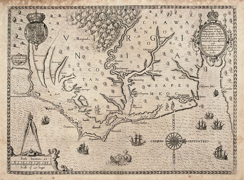
| The Carte of All the Coast of Virginia
( |
||||||||||||||||||||||||
|---|---|---|---|---|---|---|---|---|---|---|---|---|---|---|---|---|---|---|---|---|---|---|---|---|
| Автор |
|
|||||||||||||||||||||||
| Название |
The Carte of All the Coast of Virginia |
|||||||||||||||||||||||
| Описание |
English: "The Carte of All the Coast of Virginia," engraving by Theodor de Bry based on John White's map of the coast of Virginia and North Carolina circa 1585-1586. de Bry's engraving was published in Thomas Hariot's "A Briefe and True Report of the New Found Land of Virginia," published in 1588 and in Vol. 1 of Theodore de Bry’s Great Voyages, printed in French, English and German. This was the first printed map with a high degree of detail and accuracy for any part of the United States. It was the first separate map of Virginia. It was based on a manuscript map by John White from 1585, a copy of which is in the British Museum, revised for additional names and coastal detail gained from Roanoke Colony travels in 1587 and 1588. Quinn notes that White’s original drawing is accepted as the major contemporary authority on the configuration of the coastline in the late sixteenth century. The map was the same in all four editions of Harriot’s work.
John White, one of the company sent by Sir Walter Raleigh to establish an English colony on Roanoke Island in 1585, went at least twice to the Carolina coast in the 1580s. There he produced a series of drawings of the everyday life of the Native American populations. White also compiled this map of the North Carolina coast from Cape Lookout to the mouth of the Chesapeake Bay, based on the British explorations of 1585-86, which de Bry then engraved and published in 1590. |
|||||||||||||||||||||||
| Дата | 1591 | |||||||||||||||||||||||
| Надписи |
Latina: Americae pars, nunc Virginia dicta: primum ab Anglis inuenta, sumtibus Dn. Walteri Raleigh, Equestris ordinis Viri, Anno Dni. MDLXXXV regni Vero Sereniss. nostrae Reginae Elisabethae XXVII, hujus vero Historia peculiari Libro descripta est, additis etiam Indigenarum Iconibus / autore Ioanne With; sculptore Theodoro de Bry, qui et. excud.
English: Part of America, now called Virginia: first discovered by the English, by the expenses of Sir Walter Raleigh, a man of the rank of knight, in the year of the Lord 1585, indeed in the 27th (year) of the rule of our fairest Queen Elizabeth, indeed in that one's (Raleigh's) own book the history was described, also with the images of the natives added / with Ioanne With (John White) the author; with Theodoro de Bry the engraver, who also printed it |
|||||||||||||||||||||||
| Ссылки |
|
|||||||||||||||||||||||
| Источник/Фотограф | http://www.learnnc.org/lp/multimedia/6218 | |||||||||||||||||||||||
| Другие версии |
|
|||||||||||||||||||||||


Лицензирование
|
Это произведение находится в общественном достоянии в тех странах, где срок охраны авторского права равен жизни автора плюс 100 лет и менее. Это произведение находится в общественном достоянии (англ. public domain) в США, так как оно было опубликовано до 1 января 1929 года. | |
| Этот файл был определён как свободный от известных ограничений авторского права, а также связанных и смежных прав. | |
| Аннотации | Это изображение аннотировано: Просмотреть аннотации на Викискладе |
История файла
Нажмите на дату/время, чтобы посмотреть файл, который был загружен в тот момент.
| Дата/время | Миниатюра | Размеры | Участник | Примечание | |
|---|---|---|---|---|---|
| текущий | 16:48, 30 июня 2014 | | 1000 × 739 (247 КБ) | Jarekt | better version from https://www.theantiquarium.com/item/003305/de-bry-virginia |
| 07:23, 15 июня 2010 |  | 682 × 500 (127 КБ) | MarmadukePercy | {{Information |Description={{en|1="The Carte of All the Coast of Virginia," engraving by Theodor de Bry based on John White's map of the coast of Virginia and North Carolina circa 1585-1586. de Bry's engraving was published in Thomas Hariot's "A Briefe an |
Использование файла
Следующая страница использует этот файл:
Глобальное использование файла
Данный файл используется в следующих вики:
- Использование в ca.wikipedia.org
- Использование в el.wikipedia.org
- Использование в en.wikipedia.org
- Использование в es.wikipedia.org
- Использование в ja.wikipedia.org
- Использование в sr.wikipedia.org